Coastlines – Camera – Action: Community-Driven Research for Adapting to Willapa Bay’s Rapidly Changing North Shore
Final Report Update:
This project partnered with residents of North Cove, Washington, to better understand and adapt to rapid coastal erosion along Willapa Bay’s north shore. Through community focus groups, enhanced CoastSnap photo monitoring stations, and more than 500 community-submitted shoreline photos, the project combined local knowledge and coastal science to track beach change, evaluate nature-based erosion solutions, and support community-driven climate adaptation. The project has already secured additional Washington Sea Grant funding to expand this work and deepen community engagement.
Key Accomplishments
- Conducted five community focus groups to identify how coastal erosion affects residents, understand community priorities, and co-develop research questions and monitoring strategies.
- Enhanced two existing CoastSnap beach-monitoring stations in North Cove with widened viewing angles, phone cradles, and locally designed instructional signage that enables community members to contribute shoreline photos.
- Developed a new image submission pathway through MyCoast.org and partnered with the Washington Department of Ecology to collect survey and validation data for shoreline monitoring.
- Hosted a community relaunch event attended by more than 75 residents to share project goals and train participants in community-powered coastal monitoring.
- Collected and analyzed more than 500 community-submitted photographs to evaluate beach change, storm impacts, and the performance of nature-based erosion mitigation measures.
- Created an online Case Study story map for the project.
Project Update
November 2023
Coasts – Camera – Action team members participated in the Shoalwater Bay Tribe’s Yellow Brick Road Tsunami and Health Walk. At a table along the route, Connie Allen, Community Lead, used a small scale model to demonstrate how a dynamic revetment works to take energy out of the waves so that sand can be deposited onto the beach, instead of eroded away from it. Principal Investigator Roxanne Carini showed a timelapse video created from beach photos the community had previously submitted that showed how the beach has changed from 2019 to 2023. Cat Hartwell, Collaborator, created this handout which we left in the library to inform the community about next steps in the project. Graduate student Ashley Moore drummed up interest in participating in community group discussions this winter, and we informed people about the photo station removal and reinstallation.
In January and early February 2024, we plan to host community group discussions about the changing coastline. The photos uploaded to MyCoast from the North Cove beach photo stations will guide the conversations. Community members will also be able to share their own pictures. These discussions will help us understand the needs of Willapa Bay residents. The goal is to discover ways to ease the impacts of coastal change. As required, the team applied for and received IRB approval (exempt status, Category 2) by the University of Washington’s Human Subjects Division.
Photo Station Modifications and Preparation for Sharing Results:
Earl Davis, artist and metalworker, is currently designing our instructional signage for the two beach photo stations, affectionately known as Metal Marcy and Flat Jeanette. The signs will use blue and green colored anodized aluminum to catch your eye and clearly communicate instructions for how to participate. The rest of the sign will host Earl’s nature-inspired art. Earl will also be modifying the statues by enlarging the view window and adding an L-shaped cradle to help participants place their phone in a more standardized position when snapping a photo.
Developers of the MyCoast.org image repository have generously agreed to create new pathways for online photo submission for our updated beach photo stations. These will include a web-based submission that does not require downloading the MyCoast smartphone app (though the app will still be available). They will also create a landing page to showcase the latest beach change results.
Stay in the Loop:
We have developed a project webpage as part of the Willapa Erosion Control Action Now (WECAN) website where we provide a project summary and post updates. To receive email updates about project events, you can sign up here.
Overview
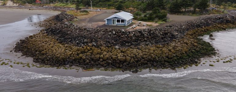
Willapa Bay’s north shore is transforming. Rising sea levels, stronger storms, and ongoing coastal erosion are reshaping the coastline, threatening homes, infrastructure, and culturally significant lands. Local residents, deeply connected to this landscape, have been actively working to protect it through the Willapa Erosion Control Action Now (WECAN) coalition.
This project builds on their efforts, bringing together university researchers and WECAN leaders to create a new way of tracking beach changes. By combining community knowledge with scientific tools like CoastSnap and Photovoice, this work will document erosion, assess mitigation efforts, and ensure those most affected have a say in shaping future solutions.
Goals
- Establish a long-term, community-led system for monitoring beach erosion through photography.
- Document how coastal changes impact local communities and ecosystems.
- Assess the effectiveness of erosion control strategies.
- Provide data that can guide local and state climate resilience planning.
- Equip the community with tools and knowledge to advocate for informed action.
Approach
This project blends community storytelling with scientific monitoring to build a clear picture of how Willapa Bay’s shoreline is shifting. WashAway No More will lead small-group discussions where residents will use photography to share their experiences with erosion and adaptation. These discussions will help shape the scientific questions explored through CoastSnap, a tool that turns crowdsourced images into measurable shoreline data.
The Shoalwater Bay Indian Tribe (SBIT), a founding member of WECAN, remains an active partner in this work. While the project focuses on areas beyond the official reservation, it includes lands that hold deep cultural significance for the Tribe. SBIT has expressed strong support and will contribute through WECAN to ensure Indigenous perspectives and knowledge are central to the research process.
Research Focus
- Community Perspectives Through Photovoice: Local residents will document and discuss coastal changes using photography. Through guided conversations, participants will highlight key concerns, strengths, and strategies for adapting to a changing shoreline.
- Quantitative Beach Monitoring with CoastSnap: Two existing photo stations will be modified to include CoastSnap technology. This will allow beachgoers to capture images that, when analyzed, provide valuable data on shoreline changes, including beach width, slope, and water levels.
- Integrating Science and Local Knowledge: By combining community-driven storytelling with scientific beach monitoring, this project will develop a well-rounded understanding of coastal erosion and the effectiveness of mitigation efforts.
Why It Matters
Coastal communities like those in Willapa Bay are facing the direct impacts of climate change, yet they often struggle to get the attention and resources needed to adapt. This project ensures their voices are heard and that local solutions are backed by both science and lived experience. By creating an accessible and sustainable monitoring system, the work will help safeguard homes, infrastructure, and cultural heritage for future generations.
Activities
- Facilitate four community discussions using Photovoice methods.
- Upgrade existing photo stations with CoastSnap technology for long-term monitoring.
- Analyze community-submitted photos to track shoreline changes over time.
- Develop an interactive exhibit to share findings with the public.
- Work with local and state agencies to incorporate data into climate resilience planning.
Expected Outcomes
- A lasting, community-driven photographic record of beach erosion.
- Increased community involvement in climate adaptation efforts.
- Scientific data that supports policies and funding for shoreline protection.
- A model for integrating community perspectives into climate science and policy.
Dissemination of Findings
- Presentations to WECAN, local leaders, and policymakers.
- A public exhibit showcasing the project’s findings.
- Online data sharing through WECAN, WashAway No More, and MyCoast.
- Contributions to CoastSnap’s global shoreline monitoring database.
- Research publications to help inform future climate adaptation strategies.
Additional Project Resources
Research Team:
Principal Investigator: Roxanne Carini, UW Seattle, Applied Physics Lab (APL)
Community Lead: Connie Allen, Pacific County Drainage District #1 Commissioner & WECAN member
Student: Ashley Moore, UW Seattle, School of Public Health, Environmental & Occupational Medicine
Collaborators: Nicole Errett, UW Seattle School of Public Health, Occupational & Environmental Medicine
Juliette Randazza, UW Seattle School of Public Health